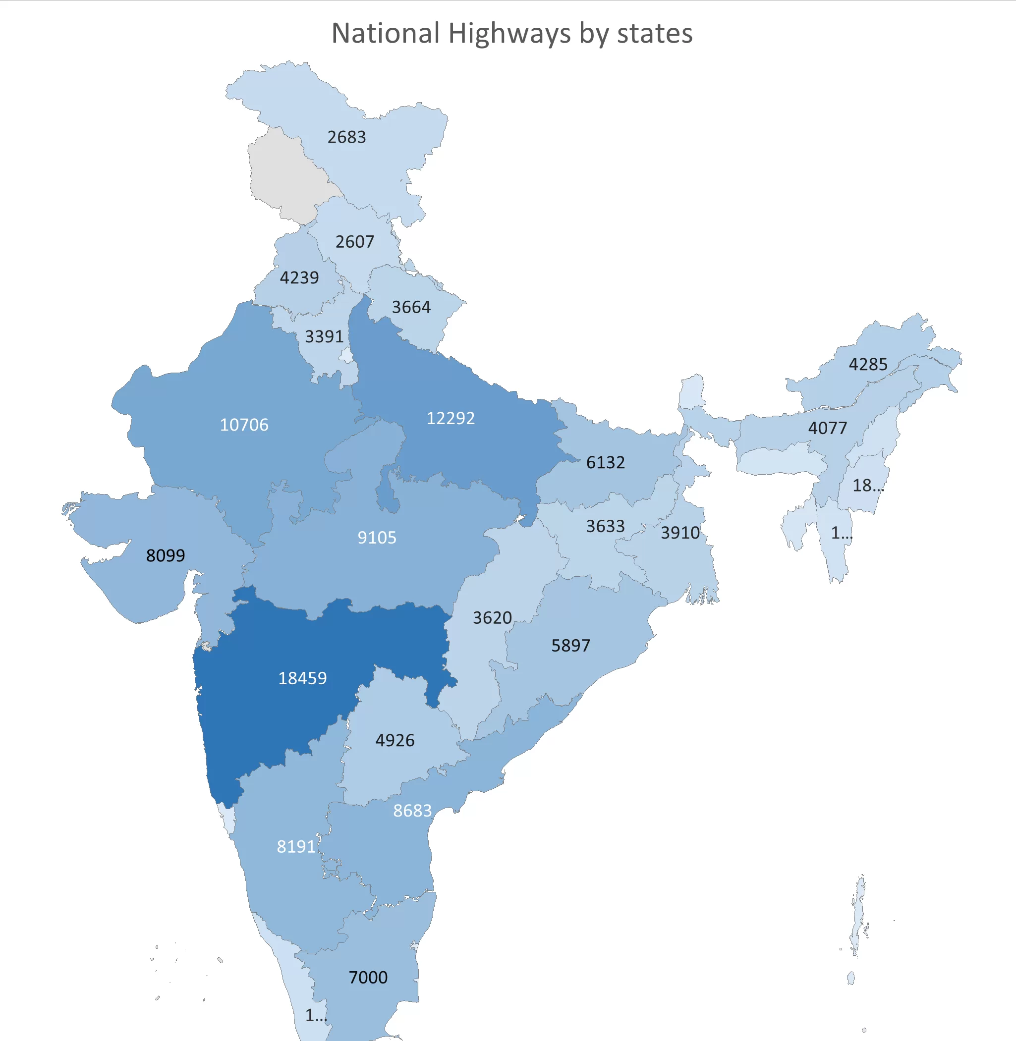
National highway in Indian states: 2014 to 2024
India has one of the largest road networks in the world, National highway in Indian states are main part of Indian Road network. India has total 146,145 KMs of National highways in 2024.
Maharashtra has the longest network of national highways in India, with a total length of approximately 18,459 km, followed by Uttar Pradesh and Rajasthan in second and third place, respectively.
The national highways (NH) are managed by the National Highways Authority of India (NHAI) and the Ministry of Road Transport and Highways (MoRTH).
Top states with most National Highway network
- Maharashtra
- Uttar Pradesh
- Rajasthan
- Madhya Pradesh
- Andhra Pradesh
- Karnataka
- Gujarat
In 2014, India’s national highway network spanned approximately 91,000 km. Over the past decade, it has expanded significantly, reaching 146,145 km in 2024. This remarkable growth reflects an addition of around 55,000 km, enhancing connectivity and infrastructure across the country.
Major National Highways in India
| National Highway | Length | From – To |
|---|---|---|
| NH44 | 3745 KM | Srinagar – Kanyakumari |
| NH27 | 3600 KM | Porbandar – Silchar |
| NH48 | 2916 KM | Delhi – Chennai |
| NH52 | 2401 KM | Ludhiana – Ankola |
| NH30 | 2116 KM | Sitarganj – Kondapali |
The NHAI has been adding more national highways year by year including New High speed Expressways like Delhi-Mumbai Expressway.
Read More: Delhi-Mumbai Expressway: An Overview
List of all states with total length of National Highway (NHs)
| State/Union Territory | 2014 | 2024 |
|---|---|---|
| Andaman & Nicobar Islands | 300 | 331 |
| Andhra Pradesh | 6,590* | 8,683 |
| Arunachal Pradesh | 2,027 | 4,285 |
| Assam | 3,634 | 4,077 |
| Bihar | 4,467 | 6,132 |
| Chandigarh | 24 | 15 |
| Chhattisgarh | 3,031 | 3,620 |
| Delhi | 80 | 157 |
| Goa | 269 | 299 |
| Gujarat | 4,694 | 8,099 |
| Haryana | 2,050 | 3,391 |
| Himachal Pradesh | 2,196 | 2,607 |
| Jammu & Kashmir | 2,319 | 2,683 |
| Jharkhand | 2,968 | 3,633 |
| Karnataka | 6,177 | 8,191 |
| Kerala | 1,700 | 1,858 |
| Madhya Pradesh | 5,116 | 9,105 |
| Maharashtra | 6,249 | 18,459 |
| Manipur | 1,452 | 1,840 |
| Meghalaya | 1,171 | 1,156 |
| Mizoram | 1,222 | 1,499 |
| Nagaland | 741 | 1,670 |
| Odisha | 4,550 | 5,897 |
| Puducherry | 53 | 64 |
| Punjab | 1,699 | 4,239 |
| Rajasthan | 7,646 | 10,706 |
| Sikkim | 149 | 709 |
| Tamil Nadu | 4,975 | 7,000 |
| Telangana | . | 4,926 |
| Tripura | 509 | 889 |
| Uttar Pradesh | 7,986 | 12,292 |
| Uttarakhand | 2,282 | 3,664 |
| West Bengal | 2,908 | 3,910 |
| ALL INDIA | 91,287 | 146,145 |